- Thread Starter
- #1
OpenSite Designer: AI Applied to Terrain Design - AulaGEO

Published 9/2024
MP4 | Video: h264, 1280x720 | Audio: AAC, 44.1 KHz, 2 Ch
Language: English | Duration: 54m | Size: 652 MB
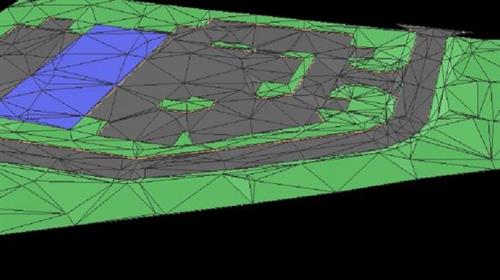
Master terrain design with OpenSite Designer, using AI tools to optimize site layouts and grading efficiently
What you'll learn
How to get started with OpenSite Designer and set up your project files.
Navigation and manipulation of 2D and 3D views within the platform.
Define the Geographic Coordinate System (GCS) and work with terrain models.
Site layout design, including defining site boundaries, building footprints, and creating parking lots.
Reviewing and optimizing site designs using AI-powered features.
Requirements
Basic concepts of surveying
Description
Course Objective: This course aims to equip learners with practical knowledge of OpenSite Designer, focusing on the use of artificial intelligence (AI) for terrain design. Through a series of hands-on exercises, students will develop skills in creating and managing terrain models, optimizing site layouts, and leveraging AI tools to streamline site design processes.What You Will Learn:How to get started with OpenSite Designer and set up your project files.Navigation and manipulation of 2D and 3D views within the platform.Define the Geographic Coordinate System (GCS) and work with terrain models.Site layout design, including defining site boundaries, building footprints, and creating parking lots.Connection design for driveways and access points.Advanced grading techniques for project sites.Reviewing and optimizing site designs using AI-powered features.Course Content: #AulaGEOExercise OverviewGetting StartedNavigationDefine GCSTerrain ModelWorking File Setup2D and 3D ViewsSite BoundaryBuilding FootprintMain DriveParking LotsReview SiteDrive ConnectionProject GradingWho This Course Is For:Civil engineers, architects, and land developers looking to improve their terrain design skills.Professionals and students interested in AI applications in site design and layout.Anyone wanting to enhance their knowledge of OpenSite Designer for terrain modeling and site planning.
Who this course is for
Civil engineers, architects, and land developers looking to improve their terrain design skills.
Professionals and students interested in AI applications in site design and layout.
Anyone wanting to enhance their knowledge of OpenSite Designer for terrain modeling and site planning.
Homepage:

Download link
rapidgator.net:
ddownload.com:

Published 9/2024
MP4 | Video: h264, 1280x720 | Audio: AAC, 44.1 KHz, 2 Ch
Language: English | Duration: 54m | Size: 652 MB
What you'll learn
How to get started with OpenSite Designer and set up your project files.
Navigation and manipulation of 2D and 3D views within the platform.
Define the Geographic Coordinate System (GCS) and work with terrain models.
Site layout design, including defining site boundaries, building footprints, and creating parking lots.
Reviewing and optimizing site designs using AI-powered features.
Requirements
Basic concepts of surveying
Description
Course Objective: This course aims to equip learners with practical knowledge of OpenSite Designer, focusing on the use of artificial intelligence (AI) for terrain design. Through a series of hands-on exercises, students will develop skills in creating and managing terrain models, optimizing site layouts, and leveraging AI tools to streamline site design processes.What You Will Learn:How to get started with OpenSite Designer and set up your project files.Navigation and manipulation of 2D and 3D views within the platform.Define the Geographic Coordinate System (GCS) and work with terrain models.Site layout design, including defining site boundaries, building footprints, and creating parking lots.Connection design for driveways and access points.Advanced grading techniques for project sites.Reviewing and optimizing site designs using AI-powered features.Course Content: #AulaGEOExercise OverviewGetting StartedNavigationDefine GCSTerrain ModelWorking File Setup2D and 3D ViewsSite BoundaryBuilding FootprintMain DriveParking LotsReview SiteDrive ConnectionProject GradingWho This Course Is For:Civil engineers, architects, and land developers looking to improve their terrain design skills.Professionals and students interested in AI applications in site design and layout.Anyone wanting to enhance their knowledge of OpenSite Designer for terrain modeling and site planning.
Who this course is for
Civil engineers, architects, and land developers looking to improve their terrain design skills.
Professionals and students interested in AI applications in site design and layout.
Anyone wanting to enhance their knowledge of OpenSite Designer for terrain modeling and site planning.
Homepage:
Screenshots

Download link
rapidgator.net:
You must reply in thread to view hidden text.
ddownload.com:
You must reply in thread to view hidden text.
